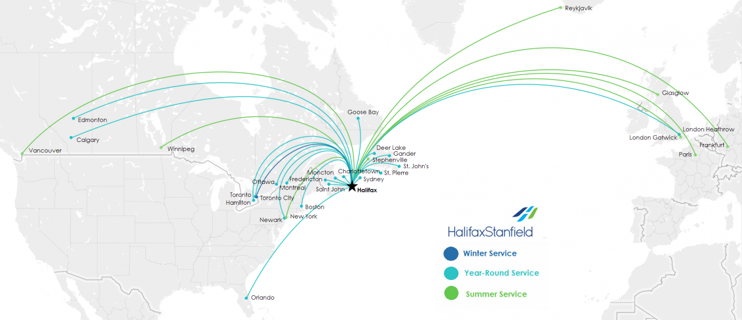
Navigate / search

Toronto West Map

Map

Delta-Header-white-bar-left
← Back
All Videos Presentation Articles Maps Contact Social Media

Map

Canadian Routes

Canada-Routes-03-17

In the past few years, Delta has added more international capacity than any major U.S. airline. With a little help from our friends, we now offer you service to more than 325 destinations on six continents. Check out our newest connections in our interactive and downloadable route maps. Visit us >

← Back
All Downloads Videos Galleries Digital Magazines Maps Contact

Map

Easy to access

© Train de Charlevoix, Caroline Perron 

Charlevoix is a safe and easily accessible destination. You will find all the equipment and installations required to hold an efficient meeting and in a post card-like decor. If all roads lead to Rome, those leading to Charlevoix stay the course when looking for breathtaking scenery.
Learn more

Airport
Charlevoix is at a 1,5-hour drive East from YQB (Québec City’s Airport acronym). Car rentals are available and regular shuttling will take you downtown where buses or the train will easily take you to Charlevoix. Porter offers direct flights from Billy Bishop Airport in Toronto (YTZ) and Air Canada offers non-stop flights from Toronto Pearson (YYZ).

Train
In the summer, the Train de Charlevoix links Québec City to Charlevoix in little more than two hours. Alongside the St. Lawrence over 125 km, you will discover fascinating scenery between river and mountain toward the Massif de CharlevoixBaie-Saint-Paul and La Malbaie. Boarding is at the Gare du Parc-de-la-Chute-Montmorency, less than 10 km from downtown Québec City.
Learn more

Road network
Driving to Charlevoix? Most of the highways from Ottawa, Toronto and Montréal lead to Québec City in no time. From there, take Route 138 and hit the Mountain Road between Petite-Rivière-Saint-François and Tadoussac, to the Easternmost area of Charlevoix. The scenery is breathtaking, between river and mountains.

ch_map_web


outaouis_banner2
← Back
All Downloads Contact Videos Galleries Maps FAM Social Media

Gallery Map

Do you know where to find Outaouais?

previous arrow
next arrow
Slider


Peterborough_Header3
← Back
All Digital Magazines Videos Contact Galleries Articles Gallery Maps Advertisement

Map

Ideally Situated


Screen Shot 2017-09-11 at 11.19.50 AM

 Peterborough & the Kawarthas is attractively located in proximity to major markets in the Greater Golden Horseshoe, Canada and the Northeastern United States. The region is located just 90 minutes northeast of Toronto and 3.5 hours from our nation’s capital in Ottawa. The city of Peterborough is right in the heart of famed Kawarthas cottage country.

View Peterborough & the Kawarthas in Google Maps >>


PKT_Townships Map2

The County of Peterborough is made up of 8 rural townships and 2 First Nations making it an ideal location for your next meeting or event.

To view an interactive map, click here.

WATERLOO-2_NewHeader
← Back
All Digital Magazines Galleries Link Maps Articles Videos Blog Contact

Map

Getting Here


Ignite Getting Here Tile - Top Photo

To learn more about where Waterloo Region is located, click here >


Airport

The Region of Waterloo International Airport (YKF) is a full service modern facility that supports commercial, corporate and general aviation. Non-stop daily air service is available with WestJet to Calgary and seasonal weekly air service is available with WestJet & Sunwing.

Learn more >


Ground Transportation Services

Limo services, bus charters, airport shuttles.

Learn more >


VIA Rail

Via runs two trains a day in each direction between Kitchener and Toronto, Guelph, London, and Sarnia; the train station is located at 126 Weber St. W, near the corner of Victoria St. in the northeast corner of downtown. Via runs three trains a day in each direction.

Coming Soon! Light Rail Transit

Set to begin service in 2018, ION is a visionary plan that will shape the community for the future by bringing Light Rail Transit (LRT) to Waterloo Region.

Learn more >


Flexible Rooms and Spaces

Map

laurentians_headerimage_v2
← Back
All Digital Magazine Videos Articles Galleries Contact Social Media Maps

Article Map

Getting here is easy

The Laurentians region is less than 60 minutes’ drive from Montreal via major highways, and just a one-hour flight from Toronto’s airports.
Impression

Mont-TremblantAirport

The Mont-Tremblant International Airport (YTM)
http://www.tourismeaerienlaurentides.ca

As soon as you land at the Mont-Tremblant International Airport, you feel the sense of well-being the Laurentian region offers: nature, log-cabin-style terminal with a fireplace and VIP service. The airport is 35 km from Mont-Tremblant, and an inexpensive shuttle service is available to take you to the station.

Porter offers direct flights from Billy Bishop Airport in Toronto (YTZ). In winter, Air Canada offers non-stop flights from Toronto Pearson (YYZ) to Mont-Tremblant (YTM).


Pierre Elliott Trudeau International Airport in Montreal (YUL)
http://www.admtl.com

Montreal-Trudeau Airport is the air gateway to Quebec. Served by some 40 carriers, it is linked by direct flights to more than 130 destinations around the world. The Laurentians region is only 30 minutes by car from Montreal’s Trudeau International Airport.

For more information about getting to the region and other general information, see: http://www.laurentides.com/en/access-information.


1 Estérel Resort
39 Chemin Fridolin-Simard, Estérel, QC J0T 1E0

2 Manoir Saint-Sauveur
246 Chemin du Lac-Millette, St-Sauveur, QC J0R 1R3

3 Hôtel Quintessence
3004 Chemin de la Chapelle, Mont-Tremblant, QC J8E 1E1

4 Tremblant Resort
1000, chemin des Voyageurs, Mont-Tremblant, QC J8E 1T1

starwoodhotelsbannernew
← Back
All Videos Galleries Articles Maps Digital Magazines Quiz Contact Social Media

Map

Conveniently Located


Laurentides/Laurentians
← Back
All Digital Magazine Videos Articles Galleries Maps Contact Social Media

Article Map

Getting here is easy

The Laurentians region is less than 60 minutes’ drive from Montreal via major highways, and just a one-hour flight from Toronto’s airports.


Mont-TremblantAirport

The Mont-Tremblant International Airport (YTM)
http://www.tourismeaerienlaurentides.ca

As soon as you land at the Mont-Tremblant International Airport, you feel the sense of well-being the Laurentian region offers: nature, log-cabin-style terminal with a fireplace and VIP service. The airport is 35 km from Mont-Tremblant, and an inexpensive shuttle service is available to take you to the station.

Porter offers direct flights from Billy Bishop Airport in Toronto (YTZ). In winter, Air Canada offers non-stop flights from Toronto Pearson (YYZ) to Mont-Tremblant (YTM).


Pierre Elliott Trudeau International Airport in Montreal (YUL)
http://www.admtl.com

Montreal-Trudeau Airport is the air gateway to Quebec. Served by some 40 carriers, it is linked by direct flights to more than 130 destinations around the world. The Laurentians region is only 30 minutes by car from Montreal’s Trudeau International Airport.

For more information about getting to the region and other general information, see: http://www.laurentides.com/en/access-information.


1 Estérel Resort
39 Chemin Fridolin-Simard, Estérel, QC J0T 1E0

2 Manoir Saint-Sauveur
246 Chemin du Lac-Millette, St-Sauveur, QC J0R 1R3

3 Hôtel Quintessence
3004 Chemin de la Chapelle, Mont-Tremblant, QC J8E 1E1

4 Tremblant Resort
1000, chemin des Voyageurs, Mont-Tremblant, QC J8E 1T1

Getting Here

Download Map